Description of Route
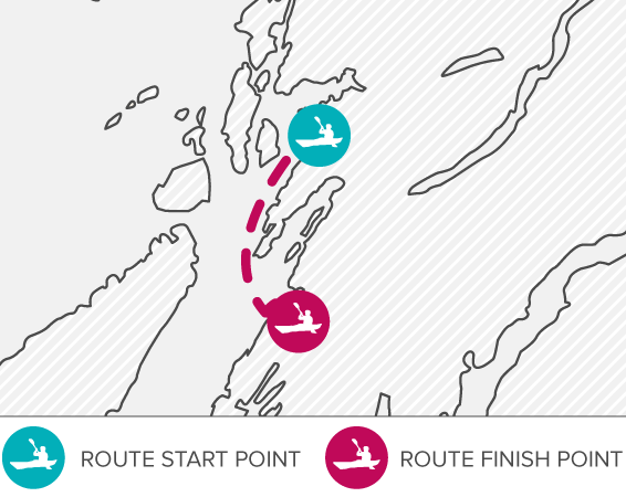
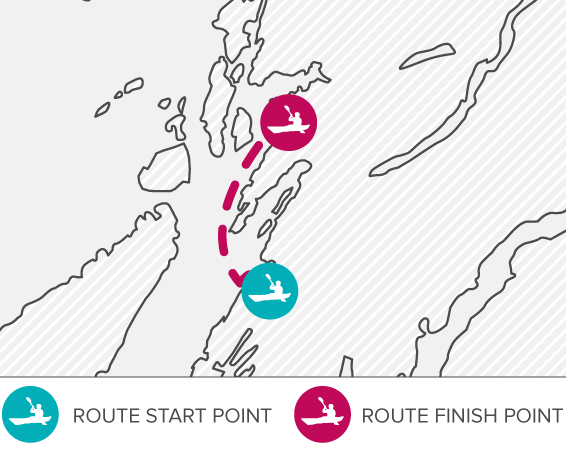
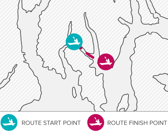
From the access point, paddle across Asknish Bay to the far point of the bay. You can now see Eilean Gamhna, your next target. From here, you choose to either paddle to the small islet of Scoul Eilean and then round the southern end of Torsa, or to Degnish Point and on around the northern end of Torsa - both are the same distance. The southern route squeezes between Luing and Torsa, whilst the northern route gives views up into Seil Sound.
You will now be approaching Cuan Sound, which has fast flowing tidal streams and ferry movements. Please see Hazards section. After carefully navigating this section, follow the coastline up past Henderson’s Rock, before making for Easdale Sound. Pass the old ruined pier, and turn in behind the ferry pier into a naturally formed bay. The gently sloping shoreline in the far corner provides the egress point.
Description of Route
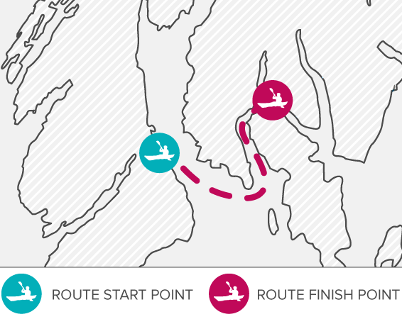
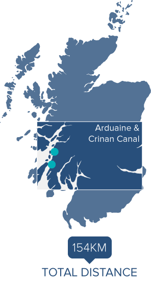
Starting off in a southerly direction, the trail follows the coast down to Craobh Haven, past a number of bays and potential rest stops down to Eilean Ona, Achanarnich Bay and Loch Beag. Continuing further, Craignish Point is soon reached, with the infamous Dorus Mòr round the corner.
This stretch of water is subject to very strong tidal flows, and can be very dangerous. Passage should only be attempted by those suitably experienced, and at slack water. Please see Hazards section. An alternative route is to portage from Loch Beag to Bàgh Dùn Mhuilig, see Additional Trail Routes & Deviations.
Once successfully navigated, set the course towards Liath-sgeir Mhòr, passing between Eilean nan Coinean and the mainland – the longest stretch across open water. Continue into Loch Crinan, past Rubha Garbh-ard, Rudha na Mòine and the stately Duntrune Castle into the mouth of the River Add.
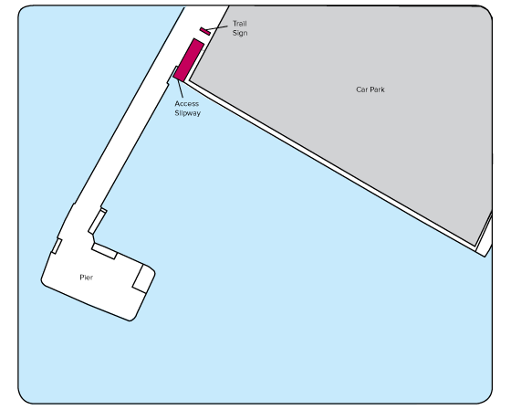
The egress point is a slipway (Grid Reference 938794) opposite Crinan Ferry, giving an easy portage up to the Crinan Canal. Aim for the Trail Marker sign. Follow the grassy path up to the canal, where you can launch directly from the purpose built low level access jetty, south of the swing bridge.
From here you can head north into Crinan to the main access point, or continue south to the Ardrishaig access point (approx. 12km).
To get to Crinan, and the main access point, follow the canal to the north, and disembark at the trail landing area. Follow the path through the woodland, and join the main path that heads down to the car park.
Additional Trail Routes & Deviations
Numerous deviations exist for these sections of the trail. When leaving from Arduaine, you can head to Ganavan via Seil Sound and Clachan Sound, passing under Clachan Bridge, the Bridge over the Atlantic. Plan passage carefully here, as fast tidal streams run. Adding Luing, Shuna or Torsa into your trip is possible, but Luing is only for the more experienced paddler.
If heading for Crinan, you could include passage around Shuna through Shuna Sound, or even Torsa and Luing passing down through the Sound of Luing.
For a more committed route, perhaps as day trips, Scarba, Lunga or the Garvellachs are possible. If heading to Scarba, the Gulf of Corryvreckan and the famous whirlpool are accessible (although only in certain tidal conditions and for those suitably experienced) as well as the northern coast of Jura. Please see Hazards section. The Grey Dogs tidal race runs between Lunga and Scarba, so again avoid unless at slack water. Please see Hazards section.
Please plan accordingly for the extra time required, and the various tidal streams that will be encountered.
If wanting to avoid the Dorus Mòr section of the Trail, a portage is possible from Loch Beag to Bàgh Dùn Mhuilig, along the B8002. Find a suitable place to egress the water on the eastern shore of Loch Beag, and follow the road to Kirkton and the access to Loch Craignish. Once afloat, you could explore the various islands within the loch, before making your way to the mainland and then down to Eilean nan Coinean. Follow the main trail description from here.
Continuing to Ardrishaig along the Crinan Canal is possible, if planning a long, committed day. Check the website for details – www.paddleargyll.org.uk Further details of the canal can be found at www.scottishcanals.co.uk
Hazards
The tidal stream at Dorus Mòr is the main hazard on this section of the trail, and must be respected by all. Spring tides can generate tidal streams of 8kn, so careful planning is necessary to allow safe passage, aiming for just before/after slack water.
Large eddies form around Garbh Rèisa, which can hamper progress if caught in them, so constant vigilance will help to read the water ahead.
When a spring flood tide and a north-westerly wind combine, rough water is produced, with many breaking waves.
Please be prepared to delay your crossing until appropriate tidal and/or weather conditions are present.
Due to the nature of this hazard, only those with appropriate experience should attempt this section of the trail.
The area between Lunga and Scarba, the Grey Dogs tidal race, is also only accessible by suitably experienced paddlers, likewise the Gulf of Corryvreckan.
Oban Harbour sees regular ferry movements, as well as various sailing vessels and motor boats, so please stay vigilant and time your crossings accordingly.
PArking
The parking area provided at Arduaine is intended solely for paddlers making use of the Argyll Sea Kayak Trail.
Arduaine is a sensitive access site, and respect must be shown for both the parking spaces available, and the local residents. Under no circumstances should any person park overnight, unless making use of the trail.
Both Crinan and Ganavan have ample parking available, although a fee is required for the latter between April 1st and September 30th.
- Accommodation
- Food & Drink
- Public Toilets
- Shop
- Accommodation, Food and Showers available locally (see insert map)
- Accommodation
- Chandlery
- Coffee Shop (April to October)
- Public Toilets
- Other facilities available along the Crinan Canal
(visit www.scottishcanals.co.uk for further information)
Working in partnership with Scottish Canals
Description of Route
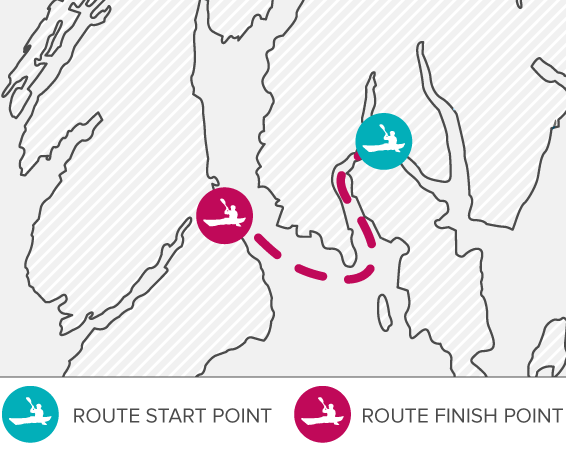
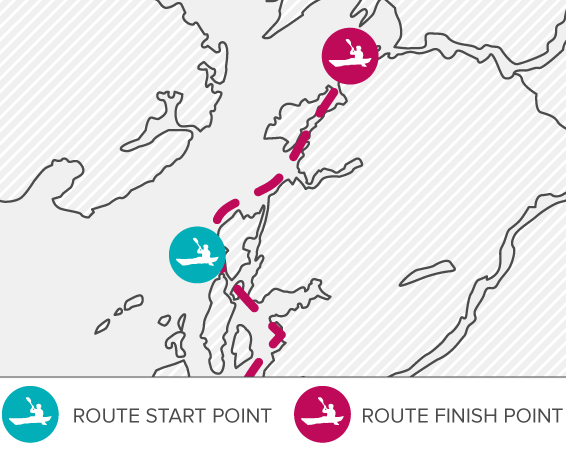
The easiest access to the sea is from the slipway by Crinan Bridge opposite Crinan Ferry, Grid Reference 938794. If starting from Crinan itself, you have a short paddle (<1km) to the swing bridge and the portage down to the slipway.
Once on the sea, paddle across Loch Crinan, passing Duntrune Castle and the headlands of Rudha na Mòine and Rudha Garbh-Ard, and then pass behind Eilean nan Coinean. Head over to Liath-sgeir Mhòr, and prepare for passage through the Dorus Mòr (please see the Hazards section for further information). Once safely through, pass Craignish Point,and head north along the coastline, taking in the stunning views across to the Gulf of Corryvreckan, and the islands of Jura and Scarba.
An alternative is to portage from Loch Craignish to Loch Beag. This is done by paddling into Loch Craignish to Bagh Dùn Mhuilig, where you can access the B8002, passing Kirkton, and on to Loch Beag. Find a suitable launching point to access the water.
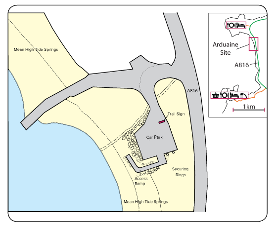
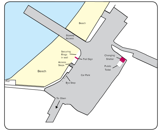
Loch Beag and Achanarnich Bay provide some potential respite locations, before continuing past Luing and Shuna up to Craobh Haven. Once here, you have the option of paddling directly to the Arduaine access point, or going via Eilean Creagach, or heading along the coastline. Use the access ramp to get to the car park.
Please note that securing rings are provided to attach your kayak to whilst you explore the area.
Crinan Canal to Ardrishaig
13km / 7nm
Description of Route
Leaving from Crinan Basin
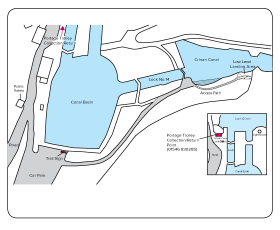
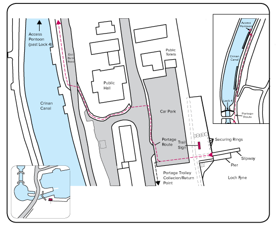
From the car park, follow the trail leading along the southern edge of the locks. Once at Lock 14, continue along the woodland path to the purpose-built landing area (beyond the mooring berths). From here, you follow the canal south east towards Crinan Bridge.
Leaving from Crinan Bridge
After negotiating your way up the slipway from the River Add (opposite Crinan Ferry) you access the canal to the south of the swing bridge, from the purpose built jetty on the east bank.
Heading south along the Canal, you pass Bellanoch Marina, and then Bellanoch Bridge. Mòine Mhòr Nature Reserve is on the northern-side of the canal, giving an opportunity to stop and admire the wildlife.
Dunardry, and the first portage, is reached next. This is approximately 750m in length and avoids locks 13 to 9. As Kayaks and canoes are not allowed to pass through the locks, a walk is necessary.
The next portage is 1km further along the canal, and this time negotiates locks 8 to 5. This is also approximately 750m long and finishes at Cairnbaan.
For both of the portages, please use the towpath on the northern side of the canal.
Specific access pontoons have been installed above locks 8 and 13, and below locks 5 and 9, making access/egress easier for canoes and kayaks.
Once back on the water, continue to follow the canal. At Oakfield Bridge there are a number of eye bolts in the wall for securing kayaks and canoes if visiting Lochgilphead.
Above Lock 4, on the northern end of the first mooring, you will find the access pontoon.
This is the start of the portage to the slipway on Loch Fyne. Follow the towpath, continue past the lock on to East Bank Road, taking the path on the left down to the main road. Carefully cross over to the car park, where you will find the slipway on the other side.
Portage trolleys are provided to assist with the portage, with storage sites at both ends – see maps for locations.
Please note that securing rings are provided to attach your kayak to whilst you explore the area.
More information on the Crinan Canal can be found at www.scottishcanals.co.uk
Additional Trail Routes & Deviations
If you’re leaving from Crinan, Loch Craignish, and the surrounding islands and land features can easily be explored. The northern end of Jura, including the Gulf of Corryvreckan is accessible and, for those looking for a longer paddle, the Grey Dogs tidal stream between Scarba and Lunga is a good option.
Staying along the Kintyre coastline Carsaig Bay is a paddle south, and if you’re looking for a couple of days on the water, the Island of Danna.
PArking
Please park responsibly at all times.
There is a designated car park for users of the trail at Arduaine, please park with due care to allow full use of the car parking spaces available. Under no circumstances should any person park overnight in Arduaine unless making use of the trail.
There is also public parking available in Crinan and Ardrishaig, next to Lock 14, and the access point slipway onto Loch Fyne respectively.
Hazards
The tidal stream at Dorus Mòr is the main hazard on the Crinan-Arduaine section of the trail, and must be respected by all.
Spring tides can generate tidal streams of 8kn, so careful planning is necessary to allow safe passage, aiming for just before slack water. Also, large eddies form around Garbh Ròisa, which can hamper progress if caught in them.
Constant vigilance will help to read the water ahead. Please also be prepared to delay your crossing until there are appropriate tidal and weather conditions.
Due to the nature of this hazard, only those with appropriate experience should attempt this section of the trail. The area between Lunga and Scarba, the Grey Dogs tidal race, and the Gulf of Corryvreckan should also only be accessed by suitably experienced paddlers.
The main hazard on the canal section of the trail is other traffic. As this is a short cut from the Sound of Jura to Loch Fyne (avoiding navigating around the Kintyre peninsula), numerous sailing and motor craft use the 14km stretch of canal to shorten their journey. All craft should pass port-to-port, but please exercise common sense when negotiating any other water user; it may be necessary to move right into the edge of the canal to allow others to pass. Please also remember that it may be difficult for the skipper to see the water immediately in front of their boat, so please make yourself as visible as possible.
Lock gates will also need to be negotiated, so some lifting of boats will be required. Portage trolleys are available for this purpose.
The towpath on the north/east side of the canal is part of the National Cycle Network (no. 78). Recreational users make significant use of this, so care must be taken on portages and rest stops.

- Accommodation, Food and Showers available locally (see insert map)

- Accommodation
- Chandlery
- Coffee Shop (April to October)
- Public Toilets
- Other facilities available along the Crinan Canal
(visit www.scottishcanals.co.uk for further information)
Working in partnership with Scottish Canals
- Accommodation
- Bank/Cash Point
- Food & Drink
- Public Toilets
- Shops
- Further facilities are available in Lochgilphead when leaving kayaks secured at Oakfield Bridge
Ardrishaig to
Crinan Canal
13km / 7nm
Description of Route
From Loch Fyne, the slipway is below the public gardens, by the public car parks (Grid ref. 853857). After landing, carefully cross the road, and follow the path uphill between the shops and the village hall. Once at the top, you will see the canal, and Lock 4 to your right. Continue your portage to the second mooring pontoon past the lock and you will find the smaller access pontoon on the northern end.
Trolleys are provided to assist with the portage, with storage sites at both ends – see maps for locations.
Once on the canal, continue to head north. After a couple of kilometres you will come across Oakfield Bridge, where there are a number of eye bolts in the wall for securing kayaks/canoes if visiting Lochgilphead to explore or re-stock.
The first portage on the canal is 4km further along the canal at Cairnbaan, where eye bolts are present in the stone walls adjacent to the canal for those wishing to secure their boat to explore the area. The portage is approximately 750m long and negotiates the Cairnbaan locks, 5 to 8. Kayaks and canoes are not allowed to pass through the locks, so a walk is necessary.
The second portage is only a kilometre further along the canal, and this time avoids the Dunardry locks, 9 to 13. Specific access pontoons for canoes and kayaks have been installed below locks 5 and 9 and above locks 8 and 13, making access/egress easier for canoes and kayaks. For both of the portages, please use the towpath on the northern side of the canal. Once past the locks, you encounter Mòine Mhòr Nature Reserve (the Great Bog) on the northern-side of the canal, giving an opportunity to stop and admire the wildlife.
Continuing north along the Canal, you pass Bellanoch Bridge, and then Bellanoch Marina. Soon you come to Crinan Bridge (no.11). This is the egress point if heading straight on to the next section of the trail. Using the new jetty immediately before the swing bridge, head through the gate on the path and veer right, down the grass slope to the slipway onto the River Add. If planning to travel all the way into Crinan, pass under the swing bridge and paddle for another kilometre until you come to Lock 14. A purpose-made, low level landing area is found on the left hand side of the canal before the mooring pontoon for the lock. Once out of the water, follow the path through the woodland, past the lock gates and down to the car park.
More information on the Crinan Canal can be found at www.scottishcanals.co.uk
Description of Route
Care must be taken to avoid any traffic entering or leaving the entrance to the canal system when leaving the slipway in Ardrishaig and heading south. Once clear of all the small craft moored in the bay, this section of the trail follows the coast down to the next access point. After passing Inverneill, and a potential rest point, the landscape becomes steeper at Creagan Beag for about 6km, before easing again as you pass Sloc nam Feàrna, and on around Barmore Island (with its north and south bay's providing an opportunity for a rest stop).
Once past the two islets at Sgeir Port a´ Ghuail, Tarbert soon appears as you enter East Loch Tarbert.
PLEASE NOTE: a new launch site is currently being developed at Tarbert Yacht Centre. More information on this site to follow in the future.
Additional Trail Routes & Deviations
If heading along the canal towards Crinan, there are no additional routes that can be added to this section of the trail. When starting from Ardrishaig, Loch Fyne becomes accessible.
Numerous bays can be explored; Port Ann, Loch Gair, and Minard Bay, as well as Otter Ferry on the eastern shoreline. The Loch extends for over 40 kilometres, so lots of scope for paddling adventures.
Hazards
The main hazard on the canal section of the trail is the other traffic using the canal. As this is a short-cut from Loch Fyne to the Sound of Jura (avoiding navigating around the Kintyre peninsula), numerous sailing and motor craft use the 14km stretch of canal so shorten their journey. All craft should pass port-to-port, but please use common sense when negotiating any other water user; it may be necessary to move right into the edge of the canal to allow others to pass. Please also remember that it may be difficult for the skipper to see the water immediately in front of their boat, so please make yourself as visible as possible.
Lock gates will also need to be negotiated, so some lifting of boats will be required.
The towpath on the north/east side of the canal is part of the National Cycle Network (no. 78), and extensively used by recreational users, so care must be taken on portages and rest stops.
PArking
Public parking is available at Crinan, Ardrishaig and Tarbert.
- Accommodation
- Chandlery
- Coffee Shop (April to October)
- Public Toilets
- Other facilities available along the Crinan Canal
(visit www.scottishcanals.co.uk for further information)
Working in partnership with Scottish Canals
- Accommodation
- Bank/Cash Point
- Food & Drink
- Public Toilets
- Shops
- Further facilities are available in Lochgilphead when leaving kayaks secured at Oakfield Bridge
- Accommodation
- Bank/Cash Point
- Food & Drink
- Shops
- Showers (at Harbour, fee required)
- Toilets
- Tourist Information
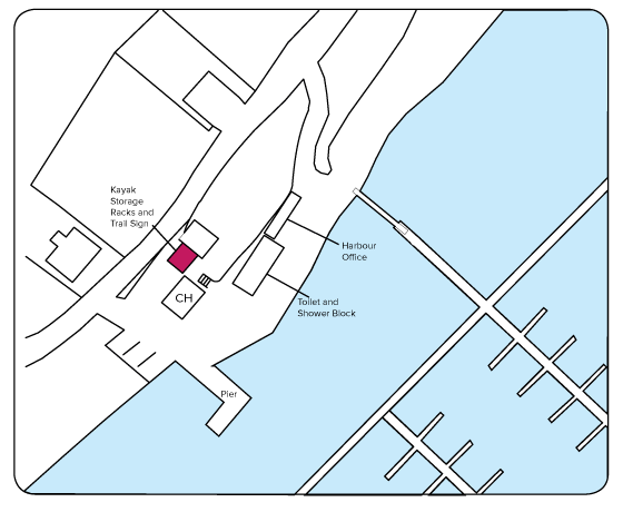
A portage trolley is provided to move kayaks to the kayak storage racks.
Please enquire in Harbour Office, 01880 820344.
Please note the Harbour opening times:
Monday – Friday Normal office hours
Saturday – Sunday Summer – extended hours
Winter – closed
Working in partnership with Tarbert Harbour Authority
Description of Route
PLEASE NOTE: a new launch site is currently being developed at Tarbert Yacht Centre. More information on this site to follow in the future.
Description of Route
PLEASE NOTE: a new launch site is currently being developed at Tarbert Yacht Centre. More information on this site to follow in the future.
Additional Trail Routes & Deviations
From Tarbert, the whole of the Inner Kintyre coastline is accessible. A journey can be made down to Skipness Point, with more committed routes available further down towards Carradale and Campbeltown. You can also access the Isle of Arran, but a longer open water crossing would be involved, so only suitable for those with relevant experience.
Another option is to explore West Loch Tarbert. This would take you out to Ardpatrick Point, and onwards to the Sound of Jura, and opens up the possibility of paddling to Gigha. Again, this would be a committed paddle, and only for those with the relevant experience.
If you head eastward from Tarbert, you are starting the next section, which ends at North Bute. You could include a paddle down to Inchmarnock and St. Ninians Bay, and explore more of the western side of Bute.
Hazards
Tarbert is a working harbour, so craft will be encountered here. Please follow the directions from the access pontoon carefully, so as to avoid any unnecessary contact.
Tide against wind conditions can make the section around Ardlamont Point challenging, as well as when heading up into Loch Fyne. If there is a northerly wind, hugging the east coastline can provide some shelter, but would add distance to this section of the Trail.
The Kyles are subjected to high usage by sailing craft, and there are a couple of popular anchorages at the northern end – Eilean Dubh, and in between Buttock Point and the Burnt Islands.
Ferries also run at numerous points on these two sections of the trail, so please be careful and avoid them at all times.
Parking
Public parking is available at Ardrishaig and Tarbert. The North Bute site has no vehicular access.
- Accommodation
- Bank/Cash Point
- Food & Drink
- Public Toilets
- Shops
- Further facilities are available in Lochgilphead when leaving kayaks secured at Oakfield Bridge
- Accommodation
- Bank/Cash Point
- Food & Drink
- Shops
- Showers (at Harbour, fee required)
- Toilets
- Tourist Information
A portage trolley is provided to move kayaks to the kayak storage racks.
Please enquire in Harbour Office, 01880 820344.
Please note the Harbour opening times:
Monday – Friday Normal office hours
Saturday – Sunday Summer – extended hours
Winter – closed
Working in partnership with Tarbert Harbour Authority
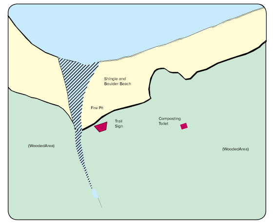
- The North Bute site is a remote wild camping area, and therefore no facilities are available other than those provided on site.
- Situated within a Site of Special Scientific Interest, so no felling of trees allowed for fire wood (Bute Forest will seek to maintain a supply for visitors to the site).
Working in partnership with Bute Forest
Description of Route
When leaving the North Bute site, head out to the left past Buttock Point and continue round to the West Kyle. Rubha Bàn is on your right as you paddle south, and then Tighnabruaich. You can restock supplies here or at Kames further south. You can paddle down either side of the Kyle, but need to be at Blindman's Bay on the Cowal coastline before you travel round the headland to Ardlamont Point.
The wind and tide can make the point a tiresome passage, so check prevailing conditions.
Once past the point and the bay, Kilbride Bay appears on the right. Continue past Sgat Beag and Sgat Mòr until Port Leathan, where you will need to cross the entrance to Loch Fyne to the point at Rubna Clach an Tràghaidh.
From here, there is less than 5km until you reach the entrance to East Loch Tarbert.
PLEASE NOTE: a new launch site is currently being developed at Tarbert Yacht Centre. More information on this site to follow in the future.
Description of Route
When leaving the wild camping site, you can either take the southern passage through the Burnt Islands, or the northern one. The latter has a stronger 5kn flow at spring tides, but is a shorter passage for all craft, so the choice is yours.
From here, you pass Balnakailly Bay, and then the ferry terminal at Rhubodach (a regular crossing, so please be cautious).
Continuing down the East Kyle and admiring the scenery, you want to be paddling on the Bute side so that you arrive at Ardmaleish Point. Rounding the headland takes you to Undraynian Point, then head across Kames Bay to Port Bannatyne. The shortest crossing is from here, and you should be aiming for the old oil rig construction site at Ardyne Point. As an alternative, you could follow the Cowal coastline, passing Bargehouse Point and arriving at Strone Point. From here you paddle across the entrance to Loch Striven and on to Port Lamont, ending up at Ardyne Point.
Toward Quay and the access point is a further 1km along the coast, at the site of the sailing club.
Kayak storage available by arrangement with Toward Sailing Club – www.towardsc.org.uk
Additional Trail Routes & Deviations
The North Bute Access Point can provide a starting point for exploration into Loch Riddon or Loch Striven, both of which offer great views on either side. If heading further south, you could embark on a circumnavigation of Bute. This could include Great and Little Cumbrae Islands, and Inchmarnock.
Further afield is the east coastline of Kintyre, and the Isle of Arran, although you would need to have the relevant experience and personal ability to undertake such a journey, as longer open water crossings are necessary.
PARKING
Parking is available at both Tarbert and Toward as North Bute is a remote site, with no vehicular access.
Hazards
Tide against wind conditions can make the section around Ardlamont Point challenging, and when heading up into Loch Fyne, If there is a northerly wind, hugging the east coastline can provide some shelter until time to cross to Tarbert, although it may be worth continuing further up the loch to make the crossing easier by paddling on the diagonal/downwind.
The Kyles are subjected to high usage by sailing craft, and there are a couple of popular anchorages at the northern end – Eilean Dubh, and in between Buttock Point and the Burnt Islands. Ferries also run at numerous points on these two sections of the trail, so please be careful and avoid them at all times.
Tarbert is a working harbour, so craft will be encountered here too.
- Accommodation
- Bank/Cash Point
- Food & Drink
- Shops
- Showers (at Harbour, fee required)
- Toilets
- Tourist Information
A portage trolley is provided to move kayaks to the kayak storage racks.
Please enquire in Harbour Office, 01880 820344.
Please note the Harbour opening times:
Monday – Friday Normal office hours
Saturday – Sunday Summer – extended hours
Winter – closed
Working in partnership with Tarbert Harbour Authority
- The North Bute site is a remote wild camping area, and therefore no facilities are available other than those provided on site.
- Situated within a Site of Special Scientific Interest, so no felling of trees allowed for fire wood (Bute Forest will seek to maintain a supply for visitors to the site).
Working in partnership with Bute Forest
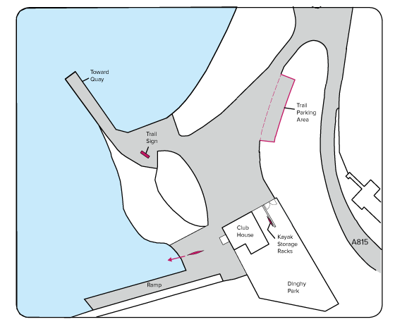
- Toilets & Showers available when club house open
- Kayak storage available by arrangement with Toward Sailing Club.
Working in partnership with Toward Sailing Club - www.towardsc.org.uk
Description of Route
Setting out from the access point at Toward Quay, whilst avoiding any sailing craft, head west along the coastline to Ardyne Point – the site of a former oil rig construction yard. After exploring, you can make the crossing to Bute, either Port Bannatyne or Undraynian Point (the latter being slightly further, but more direct). The East Kyle is entered once you pass Ardmaleish Point, with Strone Point directly north at the mouth of Loch Striven. These are prime sailing waters so please be careful to avoid the sailing craft – see Hazards section.
You can navigate up either the Cowal side or Bute side of the Kyle, with both routes offering great views over the gently sloping landscapes. Easy egress is available along much of this length for rest stops.
When approaching Colintraive, exercise caution as there is a regular ferry crossing over to Rhubodach and back. When clear to do so, paddle directly past the ferry terminal and continue towards the Burnt Islands.
The southern channel is the easiest passage, as there are lesser tidal flows, and this is a shorter route to the access point. This is found around the spit of land after Balnakailly Bay, when you will come across the shelter and fire pit. Egress anywhere along the site.
Description of Route
From the Quay, begin your passage east, aiming for Toward Point, and the Toward Point Lighthouse. Built by Robert Stevenson in 1812, this may be an early stop, but nonetheless worthwhile. Once around the point, follow the coastline north. You come across a marker buoy for a shallow area at Newton Park, where there is also a car park and a picnic area. All along this section of the trail the shoreline is gently sloping, allowing for easy egress from the water. Innellan is the first village encountered, after which a number of possible stopping points are passed along the way to Bullwood Quarry.
As you get closer to Dunoon, you will see the large beacon approximately 1km offshore marking the Gantocks, a reef of drying rocks. Whilst these shouldn't pose any problems for a paddler, please do take care if deciding to paddle to them, if only to avoid damage to your boat.
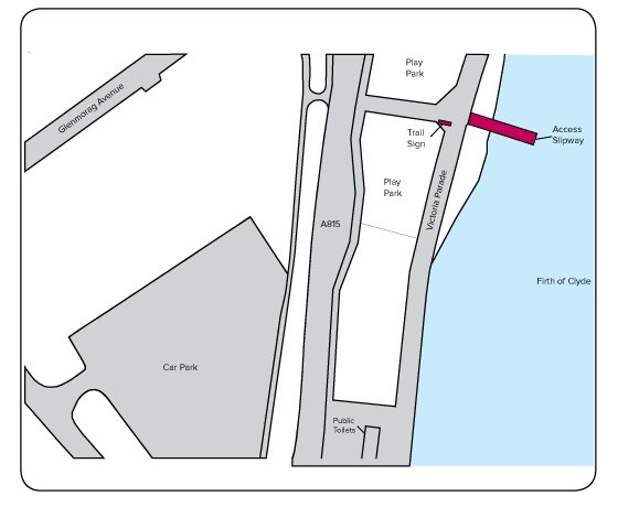
The access point with slipway is directly to the west of this feature, and brings you out between the play park areas. There are various locations nearby where you can secure your kayak.
Additional Trail Routes & Deviations
From Toward, you can further explore the Bute coastline, even completing a circumnavigation of the island. Lochs Striven and Riddon are in easy reach when heading up towards the North Bute site, as is a detour to visit Rothesay.
Great Cumbrae and Little Cumbrae are longer paddles from Toward, incorporating slightly longer crossings.
If aiming for Dunoon, Holy Loch and Loch Long are available to you a further 5km up the coast.
On the Inverclyde shoreline, you will find Wemyss Bay and Inverkip before coming across the lighthouse at Cloch Point, warning of the dangers of the Gantocks. From here, paddle across the Firth of Clyde to the Dunoon access point.
Hazards
The main hazard encountered on either of these sections of the trail is other craft on the water. Numerous sailing vessels are found in the Kyles of Bute, with more traditional shipping found in the Firth of Clyde. It is advised to stay close to the shorelines to avoid unnecessary interaction.
The sea to the south of Toward, as well as up in to the Firth of Clyde, can be subjected to considerable fetch due to the open nature of the water.
The sea to the south of Toward can be subjected to considerable fetch due to the open nature of the water, as well as up in to the Firth of Clyde. Strong tidal flows can be found in the northern channel through the Burnt Islands during spring tides, but the southern channel provides easier passage.
Please adjust plans accordingly if these conditions are encountered.
PArking
Parking is available in Toward at the sailing club, and in Dunoon in the public parking areas. North Bute is a remote site with no vehicular access.
- The North Bute site is a remote wild camping area, and therefore no facilities are available other than those provided on site.
- Situated within a Site of Special Scientific Interest, so no felling of trees allowed for fire wood (Bute Forest will seek to maintain a supply for visitors to the site).
Working in partnership with Bute Forest
- Toilets & Showers available when club house open
- Kayak storage available by arrangement with Toward Sailing Club.
Working in partnership with Toward Sailing Club - www.towardsc.org.uk
- Accommodation
- Bank/Cash Point
- Food & Drink
- Public Toilets
- Shops & Supermarkets
- Tourist Information
Description of Route
From the access slipway, found beside the play parks, launch into West Bay. The Gantocks, a reef of drying rocks marked by a large beacon, are approximately 1km to the east if choosing to visit them. Although they shouldn't pose any problems for paddlers, please do be careful.
When heading south, follow the green hillside down to Bullwood Quarry. The first picnic spot is a further 1km further south. Running parallel with the road, you come to another potential rest stop at another picnic spot before you reach Innellan.
The sloping shoreline continues down to Newton Park, where you will come across a marker buoy for the shallow area. Here you will also find picnic benches for a rest stop and a car park.
From here, the lighthouse at Toward Point is a couple of kilometres away. Built by Robert Stevenson in 1812, this is a worthwhile stopoff. Round Toward Point and follow the coastline along to Toward Quay, and the access point at the sailing club.
Kayak storage available by arrangement with Toward Sailing Club – www.towardsc.org.uk
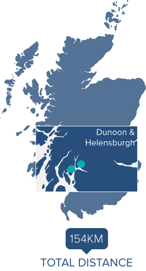
Dunoon to Helensburgh
16km / 9nm
55°56.534'N 4°56.002'W to 56°00.071'N 4°44.219'W
Grid Reference 169760 to 294821
OS Landranger Map 363 & 347 / OS Explorer Map 63 & 56
 Dunoon Local Facilities Helensburgh Local Facilities
Tidal Differences
High Water Times
Helensburgh & Gareloch – Same as Greenock
| Rhu Marina |
High water -0007 HW Greenock
Low water -0007 HW Greenock |
| Rosneath & Arrochar |
High water -0005 HW Greenock
Low Water -0005 LW Greenock |
| Lochgoilhead |
High Water +0005 HW Greenock
Low Water -0005 LW Greenock |
Description of Route
Once past the play park, and launching from the slipway, veer north and follow the coastline along West Bay. When safe to do so, pass the Dunoon Ferry Terminal, and then the East Bay. Running parallel with the road, make your way to the next ferry terminal at Hunter's Quay. Once again, when safe to do so, pass the terminal and head into the mouth of Holy Loch. From here you need to cross over to Strone Point. A slightly shorter crossing is possible between Lazaretto Point and Graham's Point if you head further into Holy Loch.
To the west of Strone Point you will come across an old pier, where the gently sloping beach provides an ideal rest stop.
Rounding the point, head into the start of Loch Long before diverting east and paddling across to Baron's Point (this can be done from the pier at Blairmore to south of Cove) the longest open water crossing of this section of the trail.
The coastline is rocky as you continue to Kilcreggan, and there’s another ferry terminal to be negotiated. After this, continue to Portkil Point, paddle past Portkil Bay towards Meikleross Bay. Another rest stop is available before the rocky outcrops of this bay. At Rosneath Point, you can aim directly towards Helensburgh, passing Perch Rock on the way.
An alternative shorter crossing is available between Castle Point and Cairndhu Point, a paddle of approximately 2km into Gare Loch.
Once at the ferry pier in Helensburgh, paddle around to the back and aim for the slipway. There are various locations nearby where you can secure your kayak.
Additional Trail Routes & Deviations
On the way south, you could cross over to the Inverclyde shoreline, and paddle down from the lighthouse at Cloch Point, passing Inverkip and Wemyss Bay. This would leave an extended open water crossing to get across to Toward Point.
Alternatively, by continuing south, Great Cumbrae becomes an option.
From Toward Point, Rothesay Bay on Bute is a short paddle away, opening up an exploration of the isle.
When heading north, Holy Loch is an easy addition to this section of the trail, as it would only add an extra 7km to your journey if you paddle to its end.
Loch Long, as well as Loch Goil, would add a considerable distance if you wish to paddle them in their entirety, and would need to be attempted as part of a multi-day expedition.
Gare Loch, containing the Faslane Naval Base, is accessible to the north of Helensburgh, either for a quick visit or a more committed day’s paddling,which will add another 20km to the journey.
The wreck of the Captayannis, commonly known as 'the Sugar Boat' lies directly between Helensburgh and Greenock, so easily visited before disembarking.
Hazards
The sea to the south of Toward can be subjected to considerable fetch d'artue to the open nature of the water, as well as up in to the Firth of Clyde. Please adjust plans accordingly if these conditions are encountered.
More traditional shipping is found in the Firth of Clyde. It is advised to stay close to the shorelines to avoid unnecessary interaction.
Four separate ferry terminals are encountered on the northern section from Dunoon to Helensburgh, and therefore pose a considerable hazard to those paddling. Please ensure you only pass the terminals when safe to do so, keeping an appropriate distance between yourself and all vessels encountered.
A number of sailing vessels can be found in Holy Loch, with a marina and moorings present. Again, please keep a safe distance at all times.
PArking
Parking is available in Toward at the sailing club, and in Dunoon and Helensburgh in the public parking areas.
- Toilets & Showers available when club house open
- Kayak storage available by arrangement with Toward Sailing Club.
Working in partnership with Toward Sailing Club - www.towardsc.org.uk
- Accommodation
- Bank/Cash Point
- Food & Drink
- Public Toilets
- Shops & Supermarkets
- Tourist Information
- Accommodation
- Bank/Cash Point
- Food & Drink
- Public Toilets
- Shops & Supermarkets
- Showers (available for a fee in swimming pool)
- Tourist Information
Helensburgh to Dunoon
16km / 9nm
56°00.071'N 4°44.219'W to 55°56.534'N 4°56.002'W
Grid Reference 294821 to 169760
OS Landranger Map 56 & 63 / OS Explorer Map 347 & 363
Helensburgh Local Facilities Dunoon Local Facilities
Tidal Differences
High Water Times
Helensburgh & Gareloch – Same as Greenock
| Rhu Marina |
High water -0007 HW Greenock
Low water -0007 HW Greenock |
| Rosneath & Arrochar |
High water -0005 HW Greenock
Low Water -0005 LW Greenock |
| Lochgoilhead |
High Water +0005 HW Greenock
Low Water -0005 LW Greenock |
Description of Route
The section starting from Helensburgh follows the Firth of Clyde down to Dunoon.
From the access slipway paddle around the pier, and when clear to do so, paddle across the mouth of Gare Loch towards Perch Rock and Culwatty Bay. A shorter crossing is possible by heading into Gare Loch and crossing from Cairndhu Point to Castle Point.
Follow the coastline around to Rosneath Point, and then Portkil Point, passing Meiklross Bay and Portkil Bay.
As you approach the eastern end of Kilcreggan, be aware of the ferry terminal and the potential for ferry movements. The coastline around Kilcreggan is a mixture of rocks and stones, but egress is possible for a rest stop.
Once you arrive at Barons Point in Cove, you will need to paddle across the mouth of Loch Long to Strone. From here, a short paddle around Strone Point into Holy Loch brings you to an old pier and a gently sloping single beach, providing a good stopping point.
Next, paddle across Holy Loch. Some may wish to paddle further into the Loch, possibly crossing between Graham's Point and Lazaretto Point, others may head to the west of the ferry terminal at Hunter's Quay. Once safely navigated past the terminal, continue following the coastline south, passing the East Bay of Dunoon, and the Dunoon Ferry Terminal.
When entering the West Bay, aim for the first slipway, which marks the access point. There are various loactions nearby where you can secure your kayak.
Additional Trail Routes & Deviations
Using Helensburgh as a starting point allows for exploration of Gare Loch, Loch Long and Holy Loch as additions to this section of the Argyll Sea Kayak Trail. Whilst Holy Loch provides a short addition, Gare Loch would give an additional 20km round trip if going to the head of the loch. Loch Long is an expedition in itself, as a round trip is over 50km, and Loch Goil is only accessible after paddling up most of Loch Long.
A shorter, more direct option, is to head to Kempock Point in Gourock Bay, then directly across to the access point in the West Bay of Dunoon. This reduces the overall section distance to 14km, but does involve longer open water crossings and is therefore only suitable for those with relevant experience.
The River Clyde is accessible to the south-east, with Dumbarton Castle 14km away, and Erskine Bridge 20km away.
The wreck of the Captayannis, commonly known as 'the Sugar Boat' lies directly between Helensburgh and Greenock, so easily visited before your onward journey.
Hazards
Numerous ferry routes are encountered, with terminals at Helensburgh, Kilcreggan, Hunter's Quay, Dunoon and Gourock to be negotiated. Please exercise caution at all times, as some ferry routes have frequent sailings. The pier at Helensburgh is used on an occasional basis, so please be mindful of this on approach.
Holy Loch is an area used extensively by sailing vessels, with both a marina and berthing's found in the vicinity.
Faslane in Gair Loch is an operational Naval Base.
PArking
Parking is available in Helensburgh and Dunoon in the public parking areas next to the access points.
- Accommodation
- Bank/Cash Point
- Food & Drink
- Public Toilets
- Shops & Supermarkets
- Tourist Information
- Accommodation
- Bank/Cash Point
- Food & Drink
- Public Toilets
- Shops & Supermarkets
- Showers (available for a fee in swimming pool)
- Tourist Information
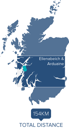
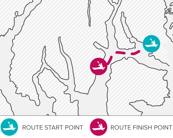
Description of Route
When leaving the access slipway at Ellenabeich, you have a choice as to which direction you take. Option one is to head north, working your way up the Sound of Insh following the western coastline of Seil. This will give views across the Firth of Lorn to Mull, but may be subject to choppy conditions if a south-westerly wind is blowing. When at the top end of the coastline at Rubha Garbh Airde, you can follow your own route through the numerous islets. If you wanted to see the Bridge over the Atlantic, then head for Eilean nam Beathach, where you will be able to see Clachan Sound, and the Bridge just a kilometre away to the south. Please see Hazards section.
The other option is to head south and navigate through Cuan Sound. Please see Additional Trail Routes and Deviations section. This route option does add an additional 6km to the total leg distance. When continuing northwards, the isolated Barrnacarry Bay provides an ideal rest location before the trail passes the entrance to Loch Feochan. Cross over to Minard Point, and then paddle round into Kerrera Sound.
You can choose which coastline you wish to follow, both offering pleasant views up to Oban. The lighthouse on Rubh´an Fheurain is easiest seen from the Kerrera-side, as well as Little Horse Shoe and Horse Shoe Bays. On the mainland-side of the sound you will see the site where the first transatlantic telephone cable came ashore at Gallanach. Further along you will encounter moorings as you pass the Kerrera ferry slipway, and again at the approach to Oban Bay.
There are numerous ferries leaving the terminal within Oban Bay, so please proceed with caution and always give way to other vessels. Following that advice, you can paddle up to the northern channel and then aim for Dunollie Castle up on the hillside.
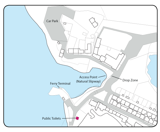
Pass between Maiden Island and Little Ganavan beach, then round Sgeir an Eitich before entering Ganavan Bay and the northernmost access point. Please use the securing rings provided.
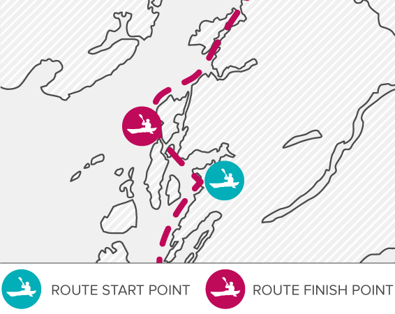
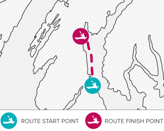
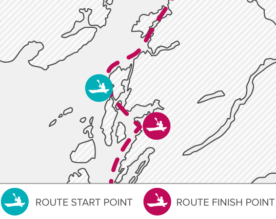
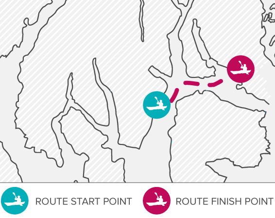
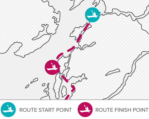
Description of Route
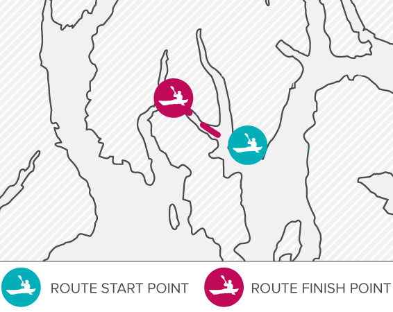
Once on the water at the natural rock slipway, make your way around the ferry terminal, and pass through Easdale Sound aiming towards the southeast. Follow the rocky coastline round to Henderson’s Rock, and continue south until you reach the entrance to Cuan Sound. Care must be taken here due to the tidal flows and the ferry movements. Please see Hazards section.
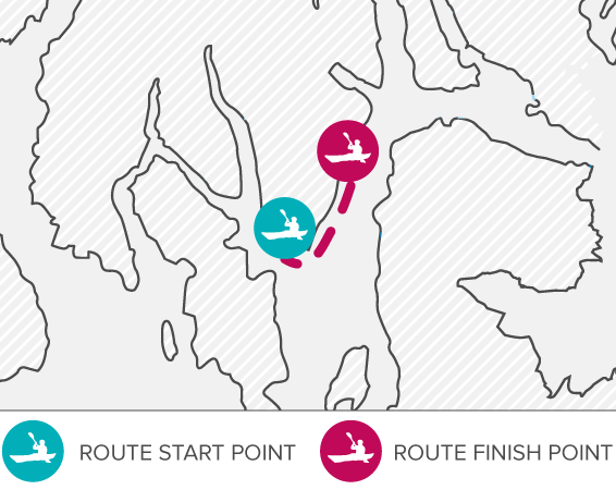
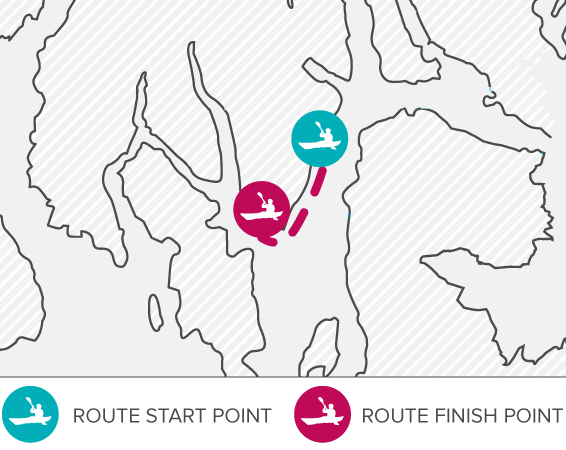
The Sound brings you out looking straight at Torsa, and you now need to decide which way around you wish to travel. The route around the top gives better views up into Seil Sound,passing the remains at Caisteal nan Con, before you head down to Degnish Point. The route around the southern end of Torsa squeezes between Torsa and Luing – great with a helping flow from the tide! It is better to stay next to Luing until ready to cross to Scoul Eilean.
From either Degnish Point or Scoul Eilean, it’s a short paddle across to the small islet of Eilean Gamhna. Come around the headland into Asknish bay and then across to the access point at Arduaine (both routes are the same distance). Please use the securing rings provided.
Additional Trail Routes & Deviations
When leaving from Ellenabeich, you have the option of paddling south, navigating through Cuan Sound, and then heading up Clachan Sound to the Bridge over the Atlantic and re-joining the trail to Ganavan. Both Cuan Sound and Clachan Sound are subjected to fast tidal flows, so passage should only be attempted at slack water. Please see Hazards section. This route option does add another 6km to the leg distance, making it 27km overall.
If considering this as an out and back paddle on a single day, please pay particular attention to the tide times and plan extra carefully, as you need to ensure that you pass through Cuan Sound at slack water.
For the more experienced paddlers, the Garvellachs are an option, as are Belnahua, Fladda and the Sound of Luing. Cullipool on Luing can be reached by following the coastline south, with a more committed route down the southern end of Lunga and the Grey Dogs tidal race possible as well.
Journeys across to Mull are feasible, but extra attention must be paid to the expected weather, as this would be a very exposed crossing, and only for those suitably experienced.
Hazards
The Cuan sound is a tidal section that demands respect. The tide squeezes between Seil and Luing at up to 6kn in spring tides. If intending to paddle this section, please make sure that you only do so at slack water.
The Cuan-Luing ferry runs very regularly, and needs to be avoided. Please ensure your own safety and that of other paddlers, by only crossing the ferry route when safe to do so.
Clachan Sound can be subjected to 5kn spring tides, especially at the narrow section by the bridge. A low spring tide will leave some sections dry, so walking may be required if you paddle at these times.
Oban Harbour sees regular ferry movements, as well as various sailing vessels and motor boats, so please stay vigilant and time your crossings accordingly.
Parking
There is a large car park at Ellenabeich. Continue right to the end of the village,following the signs, until you come to the car park at the western end. Please avoid parking in the small car park close to the ferry terminal.
Ganavan also has ample parking, although a fee is required from 1st April to 30th September.
Arduaine is a sensitive access site, and respect must be shown for both the parking spaces available and the local residents.
Under no circumstances should any person park overnight, unless making use of the trail.
- Accommodation
- Bank/Cash Point
- Food & Drink
- Public Toilets
- Regular Bus Service into Oban
- Shops & Supermarkets
- Tourist Information
- Accommodation, Food and Showers available locally (see insert map)
- Accommodation
- Food & Drink
- Public Toilets
- Shop

 Ganavan Local Facilities